district & valleys
Districts & Valleys of Khyber Pakhtunkhwa
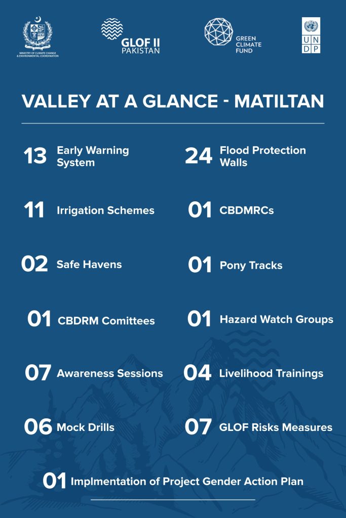
Matiltan
Matiltan
The valley is about 11km away from Kalam and 112km from Saidu Sharif Swat, Khyber Pakhtunkhwa. It has large glaciers, thick forests, and high mountain peaks. Matiltan glacier is the main glacier of the valley.
The project’s achievements in the valley include:
- The installation of 13 Early Warning Systems at high-risk locations
- The rehabilitation of 11 irrigation channels, covering over 15,569 meters, thereby improving water access for agriculture
- The establishment of 01 Community Based Disaster Risk Management Centre (CBDRMC)
- The construction of 24 flood protection structures such as gabion walls, spanning 39,615 meters
- The construction of 02 safe havens
- The development of 01 pony trek
- In terms of community empowerment, the project has undertaken 26 trainings on climate-resilient livelihoods, kitchen gardening, and disaster preparedness
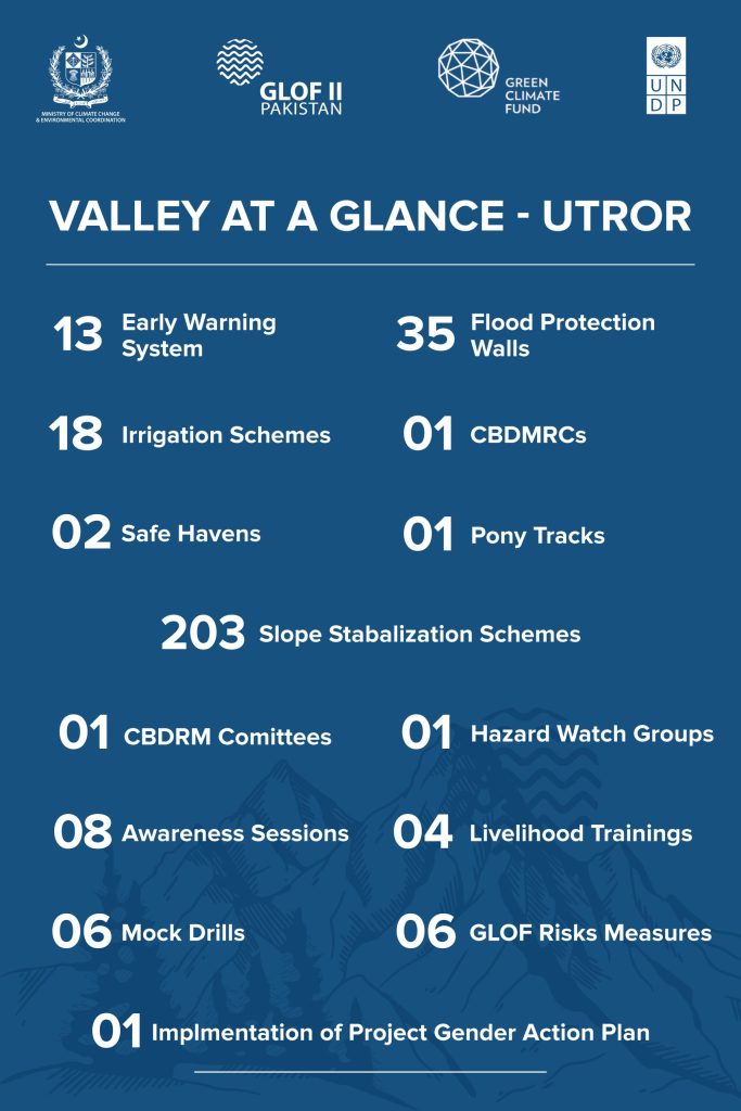
Utror
utror
The valley is located in Swat at the distance of about 16km from Kalam, Khyber Pakhtunkhwa. It is surrounded by high mountains, green pastures and waterfalls. The Gabral and Utror Rivers are the main source of irrigation in the area. The valley is surrounded by a number of glaciers including Kundol, Speen Khwor, and Izmis.
The project’s achievements in the valley include:
- The installation of 13 Early Warning Systems at high-risk locations
- The construction of 35 flood protection structures such as gabion walls, spanning 3,597 meters
- The rehabilitation of 18 irrigation channels, covering over 48,912 meters, thereby improving water access for agriculture
- The construction of 02 safe havens
- The development of 01 pony trek
- Slope stabilization covering 203 hectares of land through bio-engineering techniques significantly reducing the threats of landslides and soil erosion
- In terms of community empowerment, the project has undertaken 14 trainings on climate-resilient livelihoods, kitchen gardening, and disaster preparedness
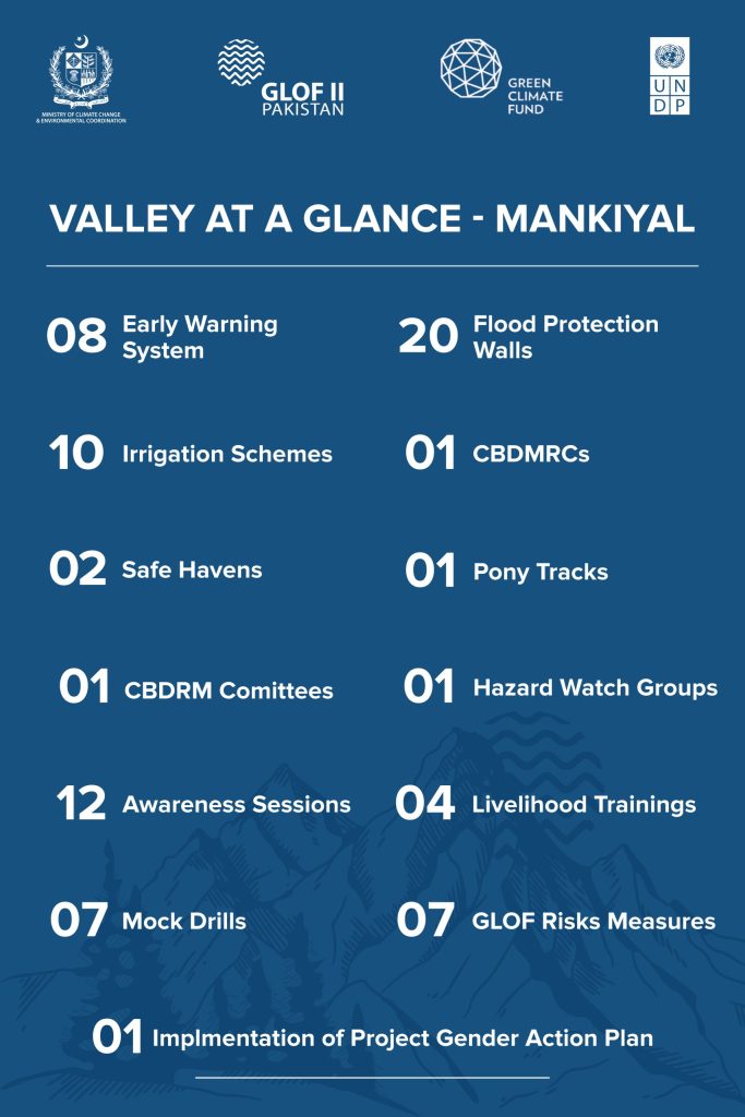
Mankiyal
mankiyal
The valley is located in Swat at the distance of about 16km from Kalam, Khyber Pakhtunkhwa. It is surrounded by high mountains, green pastures and waterfalls. The Gabral and Utror Rivers are the main source of irrigation in the area. The valley is surrounded by a number of glaciers including Kundol, Speen Khwor, and Izmis.
The project’s achievements in the valley include:
- The installation of 8 Early Warning Systems at high-risk locations
- The construction of 20 flood protection structures such as gabion walls, spanning 1,668 meters
- The rehabilitation of 10 irrigation channels, covering over 26,165 meters, thereby improving water access for agriculture
- The establishment of 01 Community Based Disaster Risk Management Centre (CBDRMC)
- The construction of 02 safe havens
- The development of 01 pony trek
- In terms of community empowerment, the project has undertaken 28 trainings on climate-resilient livelihoods, kitchen gardening, and disaster preparedness
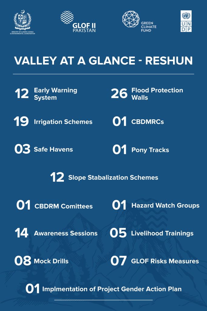
Reshun
Reshun
The valley is inhabited in the Upper Chitral district of Khyber Pakhtunkhwa (KP). Reshun Gol is the main river which is a source of irrigation for the agriculture lands owned by the people of the valley. Lot Shal and Beyu are the main glaciers in the valley.
The project’s achievements in the valley include:
- The installation of 12 Early Warning Systems at high-risk locations
- The construction of 26 flood protection structures such as gabion walls, spanning 2,296 meters
- The rehabilitation of 19 irrigation channels, covering over 43,539 meters, thereby improving water access for agriculture
- The establishment of 01 Community Based Disaster Risk Management Centre (CBDRMC)
- The construction of 03 safe havens
- The development of 01 pony trek
- Slope stabilization covering 12 hectares of land through bio-engineering techniques significantly reducing the threats of landslides and soil erosion
- Formation of 01 Ice Stupa for conservation of water
- In terms of community empowerment, the project has undertaken 33 trainings on climate-resilient livelihoods, kitchen gardening, and disaster preparedness
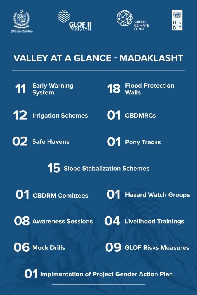
Madaklasht
Madaklasht
The valley is situated approximately 81km southeast of Chitral, Khyber Pakhtunkhwa (KP). Majority of its inhabitants depend upon agriculture and livestock rearing. The prominent glaciers of the area are Dara-e-Ailog, Andaveer, and Phushtai Glacier.
The project’s achievements in the valley include:
- The installation of 11 Early Warning Systems at high-risk locations
- The construction of 18 flood protection structures such as gabion walls, spanning 1,500 meters
- The rehabilitation of 12 irrigation channels, covering over 22,819 meters, thereby improving water access for agriculture
- The establishment of 01 Community Based Disaster Risk Management Centre (CBDRMC)
- The construction of 02 safe havens
- The development of 01 pony trek
- Slope stabilization covering 15 hectares of land through bio-engineering techniques significantly reducing the threats of landslides and soil erosion
- Formation of 01 Ice Stupa for conservation of water
- In terms of community empowerment, the project has undertaken 34 trainings on climate-resilient livelihoods, kitchen gardening, and disaster preparedness
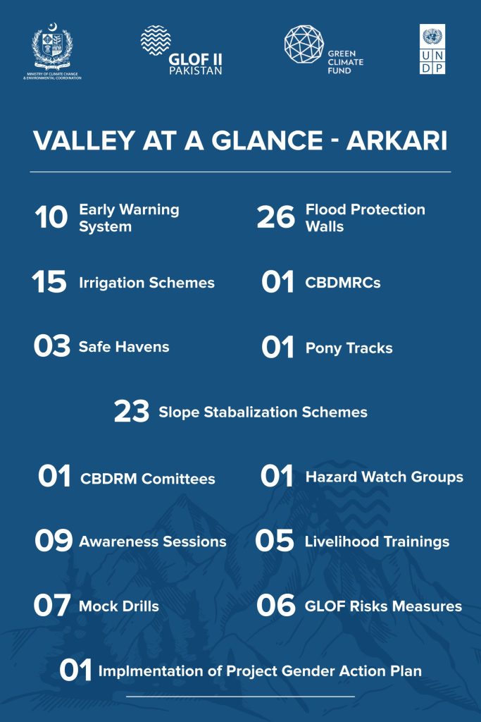
Arkari
Arkari
The valley is located at a distance of 70km from Chitral, Khyber Pakhtunkhwa (KP). An unpaved jeep-able track is bifurcated near Ruji village on main Garam Chashma-Chitral Road, the only way to access the valley. Dir / Terichmir Glacier, Warwast Glacier, and Mushti Gol Glacier are main glaciers in the area.
The project’s achievements in the valley include:
- The installation of 13 Early Warning Systems at high-risk locations
- The construction of 26 flood protection structures such as gabion walls, spanning 2,529 meters
- The rehabilitation of 15 irrigation channels, covering over 28,022 meters, thereby improving water access for agriculture
- The establishment of 01 Community Based Disaster Risk Management Centre (CBDRMC)
- The construction of 03 safe havens
- The development of 01 pony trek
- Slope stabilization covering 23 hectares of land through bio-engineering techniques significantly reducing the threats of landslides and soil erosion
- Formation of 01 Ice Stupa for conservation of water
- In terms of community empowerment, the project has undertaken 26 trainings on climate-resilient livelihoods, kitchen gardening, and disaster preparedness
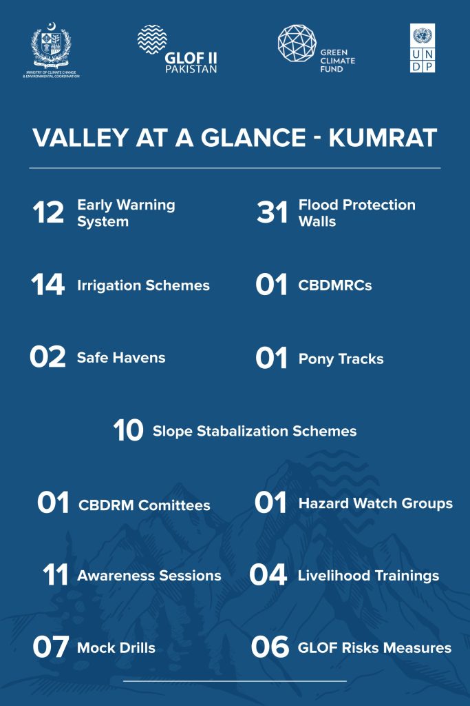
Kumrat
Kumrat
The valley is located in the Dir-Kohistan region of Khyber Pakhtunwa (KP). Shahzoor, Kundal Payeen, Kundal Bala, Gorshai, Khesheen Sir, Danoos are the main glaciers surrounding the valley.
The project’s achievements in the valley include:
- The installation of 12 Early Warning Systems at high-risk locations
- The construction of 31 flood protection structures such as gabion walls, spanning 2,529 meters
- The rehabilitation of 14 irrigation channels, covering over 28,022 meters, thereby improving water access for agriculture
- The establishment of 01 Community Based Disaster Risk Management Centre (CBDRMC)
- The construction of 02 safe havens
- The development of 01 pony trek
- Slope stabilization covering 10 hectares of land through bio-engineering techniques and micro watershed significantly reducing the threats of landslides and soil erosion
- In terms of community empowerment, the project has undertaken 26 trainings on climate-resilient livelihoods, kitchen gardening, and disaster preparedness
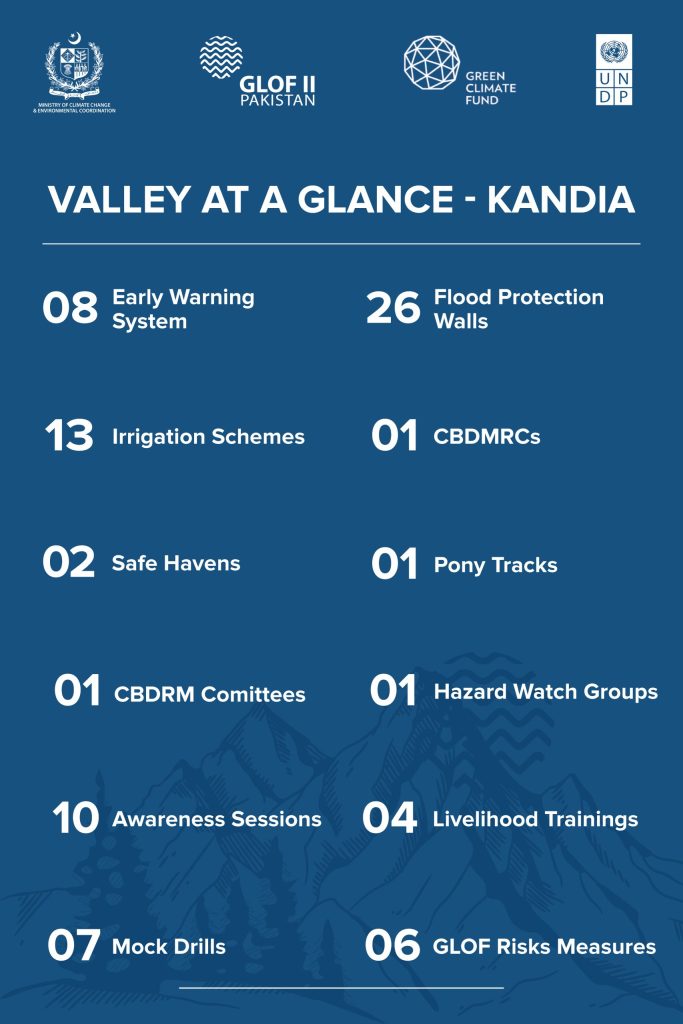
Kandia
Kandia
The valley is located in the district of Upper Kohistan, Khyber Pakhtunkhwa (KP). This disaster-prone valley is full of picturesque landscapes and untraveled high pastures with a huge potential for tourism but due lack of facilities and awareness, the valley is yet to be tested to its full potential. The valley is surrounded by Ghatti, Zarar Dara 1, and Zarar Dara 2 glaciers.
The project’s achievements in the valley include:
- The installation of 08 Early Warning Systems at high-risk locations
- The construction of 26 flood protection structures such as gabion walls, spanning 2,279 meters
- The rehabilitation of 13 irrigation channels, covering over 28,022 meters, thereby improving water access for agriculture
- The establishment of 01 Community Based Disaster Risk Management Centre (CBDRMC)
- The construction of 02 safe havens
- The development of 01 accessibility route
- In terms of community empowerment, the project has undertaken 25 trainings on climate-resilient livelihoods, kitchen gardening, and disaster preparedness