district & valleys
Districts & Valleys of gilgit baltistan
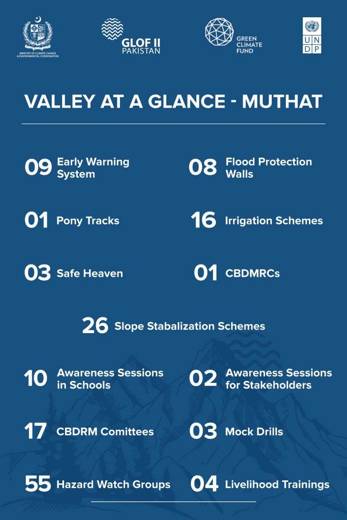
Muthat
Muthat
The valley is located 72km north of Chilas in Diamer and surrounded by Bulder, Dader, and Phia glaciers. It is home to the Yushkun tribe, with livelihoods primarily based on forests, mines, and subsistence agriculture.
- The installation of 09 Early Warning Systems at high-risk locations
- The construction of 08 flood protection structures such as gabion walls, spanning 640 meters
- The rehabilitation of 16 irrigation channels, covering over 13600 meters, thereby improving water access for agriculture
- The establishment The establishment of 01 Community Based Disaster Risk Management Centre (CBDRMC)of 01 Community Based Disaster Risk Management Centre (CBDRMC)
- The construction of 03 safe havens
- The development of 01 access route
- Slope stabilization covering 26 hectares of land through bio-engineering techniques and micro watershed significantly reducing the threats of landslides and soil erosion
- In terms of community empowerment, the project has undertaken 25 trainings on climate-resilient livelihoods, kitchen gardening, and disaster preparedness
Rupal
Rupal
The valley is surrounded by Rupal, Bazin, Lataka, Girjal, and Shai Ghiri glaciers, with livelihoods based on agriculture and livestock in a single cropping zone.
- The installation of 09 Early Warning Systems at high-risk locations
- The construction of 12 flood protection structures such as gabion walls, spanning 960 meters
- The rehabilitation of 10 irrigation channels, covering over 11,900 meters, thereby improving water access for agriculture
- The establishment of 01 Community Based Disaster Risk Management Centre (CBDRMC)
- The construction of 03 safe havens
- The development of 01 access route
- Slope stabilization covering 2.5 hectares of land through bio-engineering techniques and micro watershed significantly reducing the threats of landslides and soil erosion
- In terms of community empowerment, the project has undertaken 24 trainings on climate-resilient livelihoods, kitchen gardening, and disaster preparedness

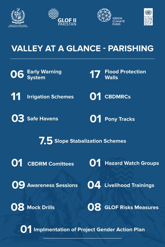
Parishing
Parishing
The valley is located in Astore Gilgit Baltistan (GB). It lies between Skardu and Bubin and is fed by Amno, Poyati Kane, and Maliki Harai glaciers, with dense forests and high-altitude terrain critical to GLOF risk.
- The installation of 06 Early Warning Systems at high-risk locations
- The construction of 17 flood protection structures such as gabion walls, spanning 1,360 meters
- The rehabilitation of 11 irrigation channels, covering over 1,100 meters, thereby improving water access for agriculture
- The establishment of 01 Community Based Disaster Risk Management Centre (CBDRMC)
- The construction of 03 safe havens
- The development of 01 access route
- Slope stabilization covering 7.5 hectares of land through bio-engineering techniques and micro watershed significantly reducing the threats of landslides and soil erosion
- In terms of community empowerment, the project has undertaken 30 trainings on climate-resilient livelihoods, kitchen gardening, and disaster preparedness
Haramosh
Haramosh
Located 65km east of Gilgit Baltistan, the valley lies in the Haramosh region of the Karakoram Range and is fed by 37 glaciers, including Mani, Baska, and Phuparash, making it highly relevant for GLOF risk management.
- The installation of 13 Early Warning Systems at high-risk locations
- The construction of 17 flood protection structures such as gabion walls, spanning 1,360 meters
- The rehabilitation of 12 irrigation channels, covering over 12,000 meters, thereby improving water access for agriculture
- The establishment of 01 Community Based Disaster Risk Management Centre (CBDRMC)
- The construction of 03 safe havens
- The development of 02 access route
- Slope stabilization covering 26 hectares of land through bio-engineering techniques and micro watershed significantly reducing the threats of landslides and soil erosion
- In terms of community empowerment, the project has undertaken 27 trainings on climate-resilient livelihoods, kitchen gardening, and disaster preparedness

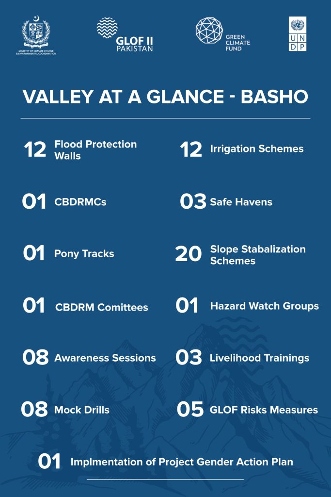
Basho
Basho
The valley lies at 2,150m in a semi-arid mountain landscape between Deosai Plains and Kachura, with steep slopes formed by glacial deposits and is fed by Serfo, Snongo, and Sarfalinga glaciers — critical for GLOF-II interventions.
- The construction of 12 flood protection structures such as gabion walls, spanning 960 meters
- The rehabilitation of 12 irrigation channels, covering over 10,100 meters, thereby improving water access for agriculture
- The establishment of 01 Community Based Disaster Risk Management Centre (CBDRMC)
- The construction of 03 safe havens
- The development of 01 access route
- Slope stabilization covering 20.04 hectares of land through bio-engineering techniques and micro watershed significantly reducing the threats of landslides and soil erosion
- In terms of community empowerment, the project has undertaken 25 trainings on climate-resilient livelihoods, kitchen gardening, and disaster preparedness
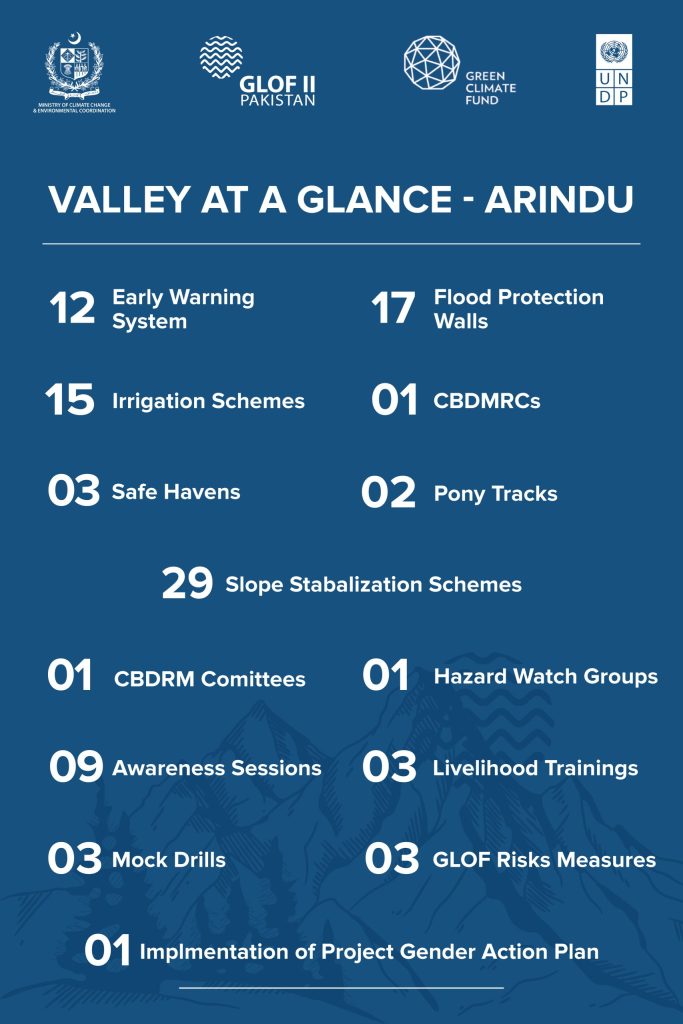
Arindu
Arindu
Located 120km from Skardu, the valley is surrounded by Chogholongma and Karfoghoro glaciers, with communities heavily reliant on agriculture and livestock — making it significant for GLOF-II risk reduction efforts.
- The installation of 12 Early Warning Systems at high-risk locations
- The construction of 17 flood protection structures such as gabion walls, spanning 1,360 meters
- The rehabilitation of 15 irrigation channels, covering over 12,750 meters, thereby improving water access for agriculture
- The establishment of 01 Community Based Disaster Risk Management Centre (CBDRMC)
- The construction of 03 safe havens
- The development of 02 access route
- Slope stabilization covering 29 hectares of land through bio-engineering techniques and micro watershed significantly reducing the threats of landslides and soil erosion
- In terms of community empowerment, the project has undertaken 18 trainings on climate-resilient livelihoods, kitchen gardening, and disaster preparedness
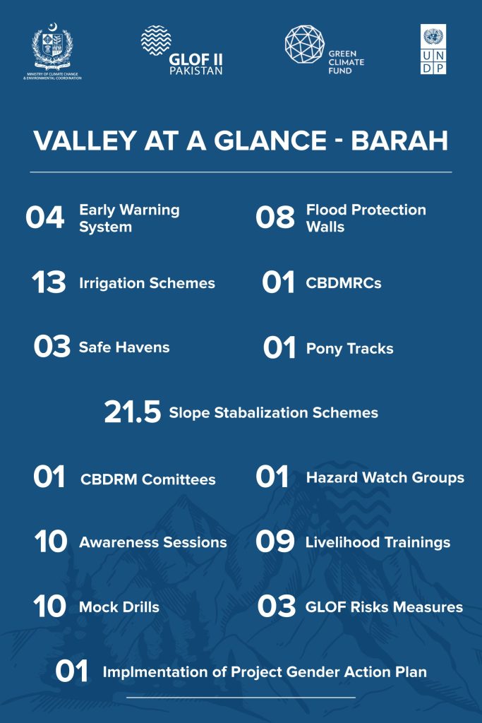
Barah
Barah
Located 5km from Ghanche HQ along the Shayk River, the valley is adjacent to Trangpi, Khenpi, Apo Bhatta, and Chugrail glaciers, making it significant for GLOF-II interventions in a high-risk glacial zone.
- The installation of 04 Early Warning Systems at high-risk locations
- The construction of 08 flood protection structures such as gabion walls, spanning 640 meters
- The rehabilitation of 13 irrigation channels, covering over 11,050 meters, thereby improving water access for agriculture
- The establishment of 01 Community Based Disaster Risk Management Centre (CBDRMC)
- The construction of 03 safe havens
- The development of 01 access route
- Slope stabilization covering 21.5 hectares of land through bio-engineering techniques and micro watershed significantly reducing the threats of landslides and soil erosion
- In terms of community empowerment, the project has undertaken 33 trainings on climate-resilient livelihoods, kitchen gardening, and disaster preparedness
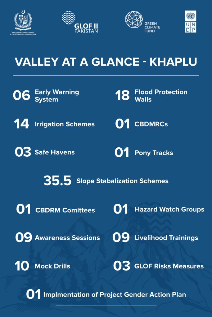
Khaplu
Khaplu
The valley is administrative center of Ghanche district, lies 103km east of Skardu and is surrounded by Chu, Trangpi, Khenpi Phong, and Strala glaciers, with agriculture and livestock as primary livelihoods—key for GLOF-II focus.
- The installation of 06 Early Warning Systems at high-risk locations
- The construction of 18 flood protection structures such as gabion walls, spanning 1,440 meters
- The rehabilitation of 14 irrigation channels, covering over 14,000 meters, thereby improving water access for agriculture
- The establishment of 01 Community Based Disaster Risk Management Centre (CBDRMC)
- The construction of 03 safe havens
- The development of 01 access route
- Slope stabilization covering 35.5 hectares of land through bio-engineering techniques and micro watershed significantly reducing the threats of landslides and soil erosion
- In terms of community empowerment, the project has undertaken 32 trainings on climate - resilient livelihoods, kitchen gardening, and disaster preparedness
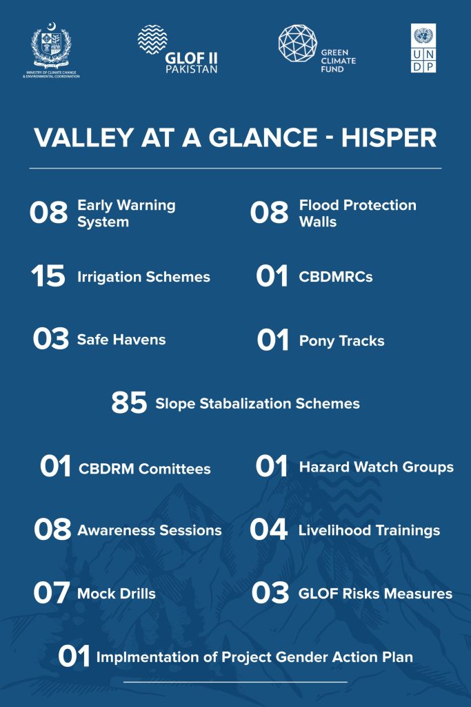
Hispar
Hispar
The valley is located 2km below the Hispar Glacier. It is about 28km away from Nagar Khas and 25km away from Hoper Valley.
The project’s achievements in the valley include:
- The installation of 08 Early Warning Systems at high-risk locations
- The construction of 08 flood protection structures such as gabion walls, spanning 640 meters
- The rehabilitation of 15 irrigation channels, covering over 15,000 meters, thereby improving water access for agriculture
- The establishment of 01 Community Based Disaster Risk Management Centre (CBDRMC)
- The construction of 03 safe havens
- The development of 01 pony trek
- Slope stabilization covering 85 hectares of land through bio-engineering techniques significantly reducing the threats of landslides and soil erosion
- In terms of community empowerment, the project has undertaken 25 trainings on climate-resilient livelihoods, kitchen gardening, and disaster preparedness
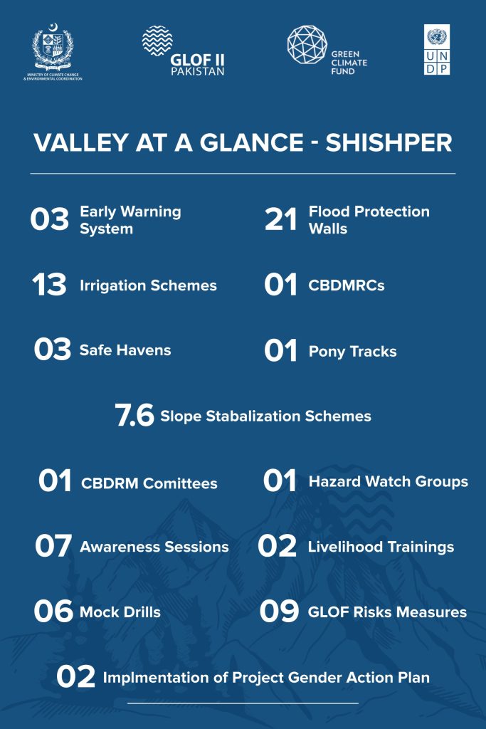
Shisper
Shisper
Shisper also known as Hassanabad is one of the constituting valleys of Hunza. Karakoram Highway (KKH) crawls through the valley with total length of 5km. The valley is located at a height of 2,100m and is a gateway to Hachinder Chish mountain. Shisper Glacier, Muchukur. Glacier, and Chash Glacier are present in the valley.
- The installation of 08 Early Warning Systems at high-risk locations
- The construction of 08 flood protection structures such as gabion walls, spanning 1,680 meters
- The rehabilitation of 13 irrigation channels, covering over 13,000 meters, thereby improving water access for agriculture
- The establishment of 01 Community Based Disaster Risk Management Centre (CBDRMC)
- The construction of 03 safe havens
- The development of 01 pony trek
- Slope stabilization covering 85 hectares of land through bio-engineering techniques significantly reducing the threats of landslides and soil erosion
- In terms of community empowerment, the project has undertaken 25 trainings on climate-resilient livelihoods, kitchen gardening, and disaster preparedness
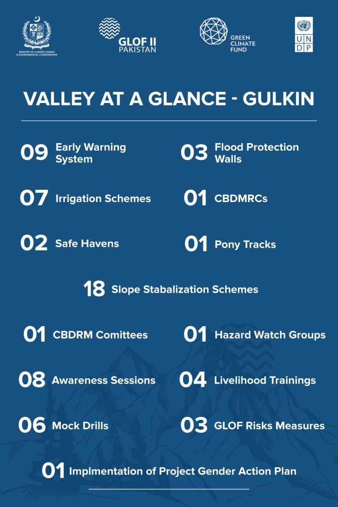
Ghulkin
Ghulkin
The valley is located in the Gojal Tehsil of Gilgit Baltistan (GB). It is situated at an elevation of 2,700m above sea level and is surrounded by majestic peaks of the Karakoram range.
The project’s achievements in the valley include:
- The installation of 09 Early Warning Systems at high-risk locations
- The construction of 03 flood protection structures such as gabion walls, spanning 3,050 meters
- The rehabilitation of 07 irrigation channels, covering over 700 meters, thereby improving water access for agriculture
- The establishment of 01 Community Based Disaster Risk Management Centre (CBDRMC)
- The construction of 02 safe havens
- The development of 01 access route
- Slope stabilization covering 18 hectares of land through bio-engineering techniques and micro watershed significantly reducing the threats of landslides and soil erosion
- In terms of community empowerment, the project has undertaken 40 trainings on climate-resilient livelihoods, kitchen gardening, and disaster preparedness
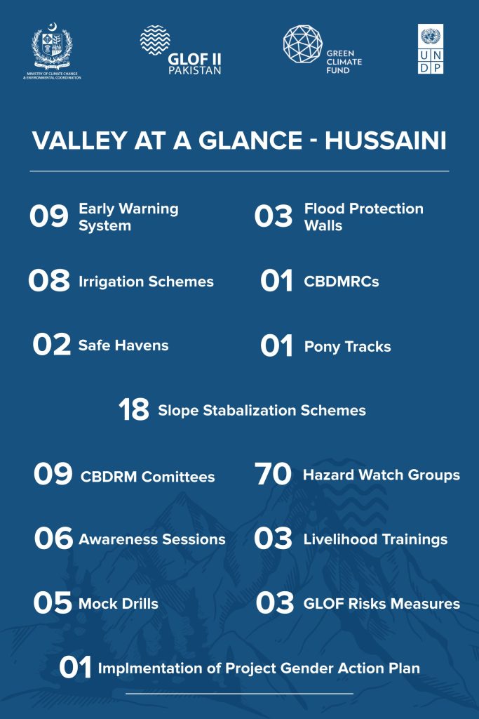
Hussaini
Hussaini
The valley is located in the Gojal Tehsil of Gilgit Baltistan (GB). The valley features the Hussaini Glacier and the Khujarab River, with the Karakoram Highway (KKH) running through the village.
The project’s achievements in the valley include:
- The installation of 09 Early Warning Systems at high-risk locations
- The construction of 03 flood protection structures such as gabion walls, spanning 3,050 meters
- The rehabilitation of 08 irrigation channels, covering over 700 meters, thereby improving water access for agriculture
- The establishment of 01 Community Based Disaster Risk Management Centre (CBDRMC)
- The construction of 02 safe havens
- The development of 01 access route
- Slope stabilization covering 18 hectares of land through bio-engineering techniques and micro watershed significantly reducing the threats of landslides and soil erosion
- In terms of community empowerment, the project has undertaken 40 trainings on climate-resilient livelihoods, kitchen gardening, and disaster preparedness
Shimshal
Shimshal
The valley is a village located in Gojal Tehsil of Hunza District, in the Gilgit Baltistan being the largest valley in the region. It lies at an altitude of 3,100m above sea level and is the highest settlement in the district. Shimshal includes major glaciers like Verjerab, Khurdpin, Yukshun, and Yazghal.
The project’s achievements in the valley include:
- The installation of 06 Early Warning Systems at high-risk locations
- The construction of 10 flood protection structures such as gabion walls, spanning 800 meters
- The rehabilitation of 10 irrigation channels, covering over 10,200 meters, thereby improving water access for agriculture
- The establishment of 01 Community Based Disaster Risk Management Centre (CBDRMC)
- The construction of 03 safe havens
- The development of 01 pony trek
- Slope stabilization covering 24 hectares of land through bio-engineering techniques significantly reducing the threats of landslides and soil erosion
- In terms of community empowerment, the project has undertaken 29 trainings on climate-resilient livelihoods, kitchen gardening, and disaster preparedness
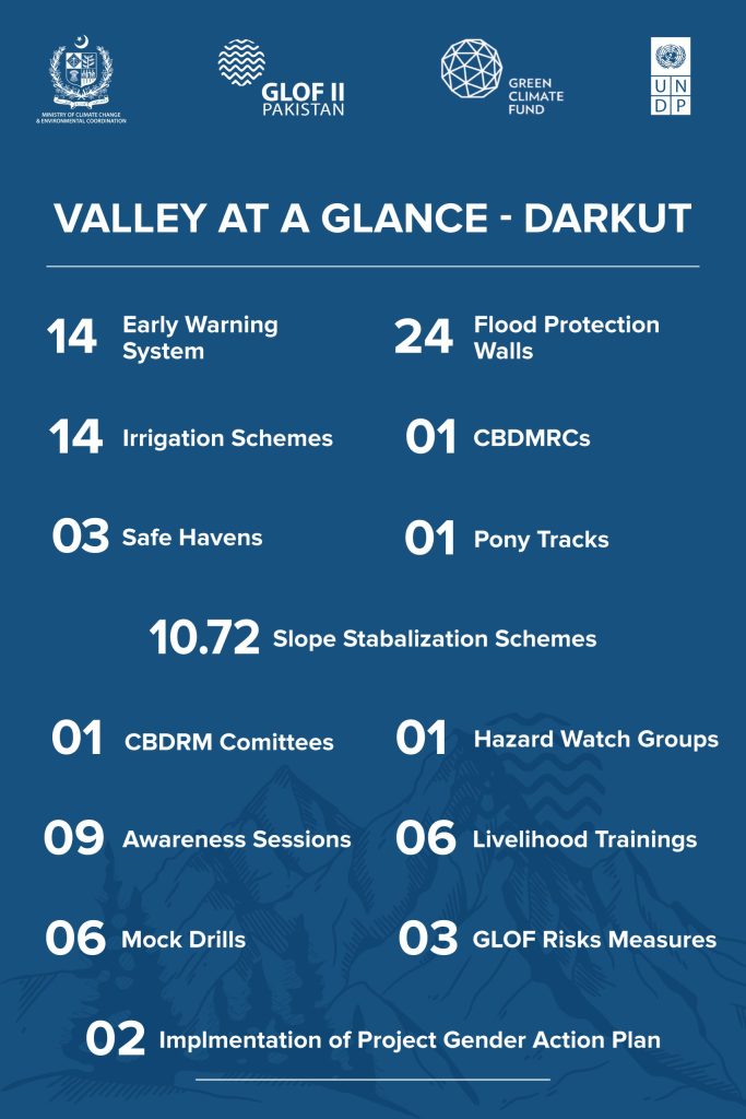
Darkut
Darkut
Located 65km from Gahkuch in Ghizer, the valley is surrounded by Ghorochi, Mandahar, Ghamubar, Kharay Ghal, and Garum Chashma glaciers, making it significant for GLOF-II interventions.
- The installation of 14 Early Warning Systems at high-risk locations
- The construction of 24 flood protection structures such as gabion walls, spanning 1,920 meters
- The rehabilitation of 14 irrigation channels, covering over 11,900 meters, thereby improving water access for agriculture
- The establishment of 01 Community Based Disaster Risk Management Centre (CBDRMC)
- The construction of 03 safe havens
- The development of 01 access route
- Slope stabilization covering 10.72 hectares of land through bio-engineering techniques and micro watershed significantly reducing the threats of landslides and soil erosion
- In terms of community empowerment, the project has undertaken 26 trainings on climate-resilient livelihoods, kitchen gardening, and disaster preparedness
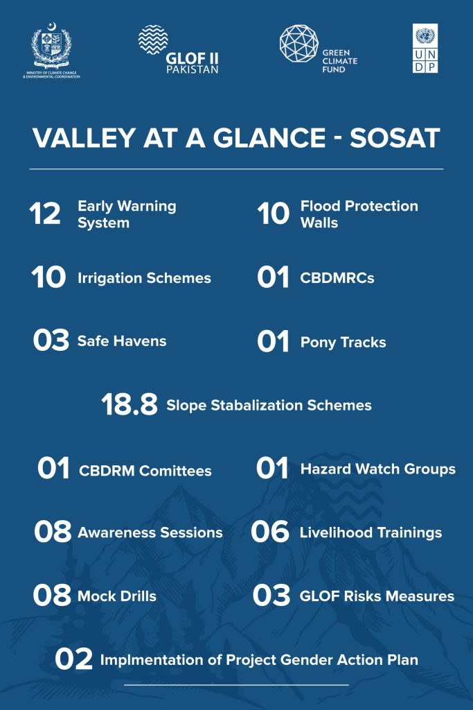
Sosat
Sosat
Located 100km from Gahkuch in Ghizer, the valley comprises 10 villages and is fed by the Sosat Glacier, with pastureland and natural water channels—relevant for GLOF-II planning and risk reduction.
- The installation of 12 Early Warning Systems at high-risk locations
- The construction of 10 flood protection structures such as gabion walls, spanning 800 meters
- The rehabilitation of 10 irrigation channels, covering over 1,000 meters, thereby improving water access for agriculture
- The establishment of 01 Community Based Disaster Risk Management Centre (CBDRMC)
- The construction of 03 safe havens
- The development of 01 access route
- Slope stabilization covering 18.8 hectares of land through bio-engineering techniques and micro watershed significantly reducing the threats of landslides and soil erosion
- In terms of community empowerment, the project has undertaken 32 trainings on climate-resilient livelihoods, kitchen gardening, and disaster preparedness
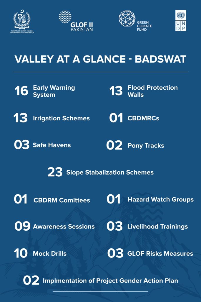
Badswat
Badswat
Located 52km from Gahkuch in Ghizer, the valley is surrounded by Badsawat, Pithkormin, Jingal Lak, Kachiston, and Yaaz glaciers, making it a key area for GLOF-II risk reduction and resilience efforts.
- The installation of 16 Early Warning Systems at high-risk locations
- The construction of 13 flood protection structures such as gabion walls, spanning 1,040 meters
- The rehabilitation of 13 irrigation channels, covering over 13,000 meters, thereby improving water access for agriculture
- The establishment of 01 Community Based Disaster Risk Management Centre (CBDRMC)
- The construction of 03 safe havens
- The development of 02 access route
- Slope stabilization covering 23 hectares of land through bio-engineering techniques and micro watershed significantly reducing the threats of landslides and soil erosion
- In terms of community empowerment, the project has undertaken 27 trainings on climate-resilient livelihoods, kitchen gardening, and disaster preparedness
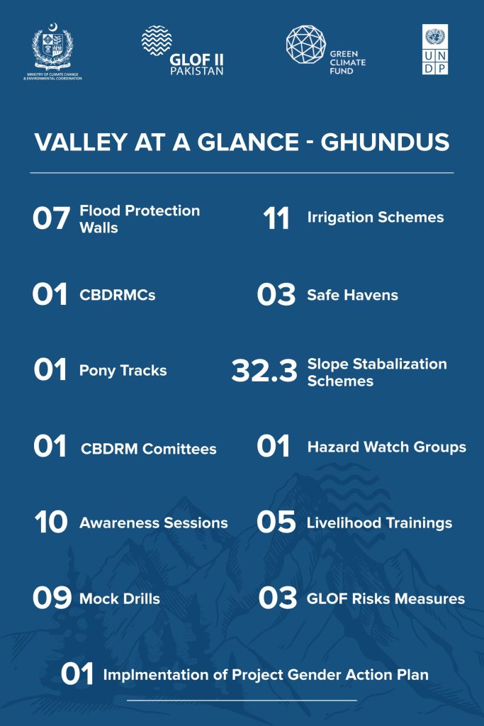
Ghundus
Ghundus
Situated about 100km southeast of Skardu in Kharmang district, the valley is surrounded by Staay Mangale and Zing Gar glaciers, with agriculture and livestock-based livelihoods—key for GLOF-II risk mitigation.
- The construction of 07 flood protection structures such as gabion walls, spanning 560 meters
- The rehabilitation of 11 irrigation channels, covering over 11,000 meters, thereby improving water access for agriculture
- The establishment of 01 Community Based Disaster Risk Management Centre (CBDRMC)
- The construction of 03 safe havens
- The development of 01 access route
- Slope stabilization covering 32.32 hectares of land through bio-engineering techniques and micro watershed significantly reducing the threats of landslides and soil erosion
- In terms of community empowerment, the project has undertaken 28 trainings on climate-resilient livelihoods, kitchen gardening, and disaster preparedness